By continuing you agree to eChinacities's Privacy Policy .
 Sign up with Google
 Sign up with Facebook

Q: Has anyone trekked along karakoram highway in Xinjiang?
Any feedback? Comments?
12 years 21 weeks ago in Transport & Travel - China

there is no such a frequrnt way over there as there's climate is always unfavourable to travel...

OK. Let's consider this one. Not a bad idea, but not something that I would recommend in the winter, again, and not something that I would recommend alone. First, you would need to trek along this highway during daytime hours only. Secondly, you would need to be assured that you have travel rights as a foreigner to all parts of this highway. Thirdly, I would probably do a good part of it on bicycle.
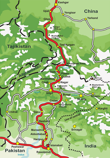
Here's a map of the highway:
Here is some general information about the highway:
The Chinese Section of the Karakoram Highway follows the north-south Sarykol ('Yellow Lake') valley just west of the Tarim Basin. The road from Kashgar goes southwest about 80 km and then turns west to enter the Gez (Ghez) River canyon between Chakragil mountain on the north and Kongur mountain on the south. From the Gez canyon the population becomes Kirgiz. Having climbed up to the valley, the road turns south past Kongur, Karakul Lake and Muztagh Ata on the east. Below Muztagh Ata a new road goes west over the Kulma Pass to join the Pamir Highway in Gorno-Badakhshan, Tajikistan. The main road continues over a low pass (where the population becomes Tajik) and descends to Tashkurgan. Further south a valley and jeep track leads west towards the Wakhjir Pass to the Wakhan Corridor. Next the road turns west to a checkpost and small settlement at Pirali, and then the Khunjerab Pass, beyond which is Pakistan, the Khunjerab River and Hunza.
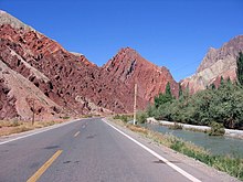
Here's a picture of the highway: